
Welcome to our initial Travelogue post of 2024. A Thousand Memories in a Thousand Miles summarizes our first two months on the road.
Into our 7th year of full-time RV’ing, we have hit the deck running! After spending the winter at Nellis AFB in Las Vegas, NV where we enjoyed the hiking opportunities at Valley of Fire State Park, Red Rock Canyon, and the Lake Mead Recreation Area. Day roadtrips to Gold Butte National Monument, Death Valley, Nelson Ghost town at Eldorado Canyon. We also spent a lot of time at the gym again this year. Our routine efforts last year significantly made our hiking adventures much less painful and more enjoyable, and we anticipate similar success this year.
This year’s journey begins with a trip down to Tucson to visit family and friends and a few days to stroll through memory lane at Saguaro National Park, a chance to see the giant cactus and spend some time with our daughter. After a brief stay in Phoenix and a hike at Lake Pleasant Regional Park we were ready to venture off to the Mogollon Rim area of Arizona to the mountain town of Show Low. The drive from Phoenix to Payson was enjoyable, as we climbed into the higher elevation we encountered significant snow, fortunately none of it was on the roadway!
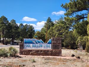
Fool Hollow State Park is a beautiful campground with paved full hook up sites. When we were checking in, we received a thunderous welcome as the snowfall was quite a surprise!!
Our short stay in Show Low provided us with the opportunity to venture up to the Petrified Forest National Park.
Petrified Forest Flickr Gallery
A short 60 mile drive up state hwy 61/180A and US hwy 180 to the southern National Park entrance. We made several scenic stops along the way for photo opportunities at Martha’s Butte, the Crystal Forest, the Jasper Forest, the Agate Bridge, and our favorite loop at Blue Mesa. After a nice stroll amidst the petrified ruins with Deb and Zeus we continued our drive toward the Painted Desert portion of the park. There are several scenic overlooks at Whipple, Nizhoni and Pintado Point but our goal was to reach the picnic area at Hozo Point. We had this place to ourselves and had a feast! A short stop at the visitor center, we were soon off to Holbrook via I-40 and down state highway 77 and back to Show Low.


Our second day, (with a full picnic basket) was a scenic drive down to the Fort Apache Historical Park where we visited the museum and learned a little about the White Mountain Apache Tribe and the role they played as US Army scouts in the so-called Apache Wars. After a short walking/driving tour of the grounds, we drove about five miles to visit the Kinishba Ruins.
These large pueblo ruins contained several masonry buildings constructed between 1250 and 1350 A.D. by the pre-Columbian Mogollon culture. In 1931, archaeologist Byron Cummings began an extensive excavation and hosted a museum with artifacts on site. All of the artifacts are now located at the Arizona State Museum in Tucson.


Our daily adventure was complete after we took a short drive down to Salt River Canyon where we had a nice walk along the river and a tailgate picnic at the rest stop.


The last day at Fool Hollow Lake was a walk around the lake in the brisk morning air. Many campers were on the shore fishing, noisy Canadian geese pierced the solitude of our stroll and the fresh evergreen scent made for a very pleasant start of the day.
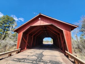
Our last scenic stop was to find the Pinedale covered bridge. Deb and I had made so many trips to Pennsylvania to see the covered bridges of Lancaster County, we were compelled to check it out.
We have been very fortunate with our travel plans and the forecasted weather patterns in our path of travel. Deb and I had to call a Travelogue audible! We were headed for Canyon de Chelly & Monument Valley (Valley of the Gods) for the next 7 days and the forecast was for high winds and “wintry mix” which doesn’t bode well for RV dry camping! We considered staying a few more days at Fool Hollow but the same front with same weather was inbound. Being parked under tall evergreens with snow is NOT the place to be! The solution was quite simple, we extended our stay in Page, Arizona and we were safely on our way.
This is NOT our first visit to Page, Arizona. Every time we are in this area, we find more to see & do and extend our opportunities for hiking and off-road Jeep days. This year was no exception. We have made it a practice to visit the local Bureau of Land Management (BLM) or US Forest Ranger District Office to find out the condition of back roads and hiking trails. A lack of preparation and situational awareness can lead to a disastrous day!
Alstrom Point and Trailhead were only 41 miles from our RV Park in Page, at Big Water, after 19 miles on US Highway 89, we were off on Smokey Mountain Road for some dirt and dust. This BLM backroad was in pretty good shape, some washboard, some sand as we neared the point. We made several stops along the way marveling over the multicolored mesas, buttes, and rimrock. Pillars, chimneys of red and hoo-dos dotted the landscape.


There are two map markers here, Alstrom Point Trail Head and Alstrom Point. The 2 mile “Trail” can be hiked, biked, or driven in 4WD High Clearance vehicles. I would discourage folks from driving their passenger vehicles but there’s evidence that many have by the looks of the oil pan skid marks on some of the rocky areas. Deb was constantly looking for tire tracks as we crawled across the near solid rock surface in many places, we gently navigated over ruts and rocks and neared the Point, the dark gray skies were now overhead, and a cloud burst opened up with snow. We watched in awe as the storm blew by, over Gunsight Mesa, Glen Canyon, Tower Butte and Lake Powell. Seemed appropriate to now have our picnic and watch the remains of the front move off over the desert plains. The magnificent vista views were beyond words. We retraced our path off the trail and back onto the road. The afternoon cloud show was not over, we had several opportunities for taking pictures of the rugged landscape and the stormy skies. Soon we passed Wiregrass Canyon Trailhead, through the muddy wash and back to the highway, content with this day’s exploration.
Our next day trip was planned to be a revisit to some of our favorite scenic spots along the Colorado river. Navajo Bridge, Lee’s Ferry, Marble Canyon, and the dynamic Vermilion Cliffs. A short diversion to a Colorado River rapids overlook, the 1000-foot cliffs provided a spectacular view of the beginning of the Grand Canyon.
26 miles west of the Navajo Bridge is House Rock Valley Road. This 29-mile off-road scenic backway provides some of the iconic hikes available in the Southwest.
- Buckskin Gulch
- Cobra Arch
- Coyote Buttes
- Coyote Wash
- Paria River
- The Wave
- White Pocket
- Wire Pass Trailhead
We’ve done the Lottery in an attempt to get a permit to hike The Wave without success. Abundant literature is available to show alternative hikes in this area. Access to many is limited due to road conditions. Nearly ALL require 4WD & High Clearance. Out here, with little or no cell service, it’s going to be a hike just to make that call, it’s also been said that getting a vehicle towed out of these remote area easily exceeds one thousand dollars.


The White Pocket is characterized by its swirling and intricate patterns of white and red Navajo sandstone, which have been sculpted over millions of years by the forces of wind and water erosion. The result is a mesmerizing landscape that resembles a frozen wave or a surreal painting. It’s ALWAYS been on our bucket list so we committed to drive as far as our Gladiator would take without putting ourselves in danger or at risk. Ten miles of decent road with minimal wash-boarding and ruts got us to the last stretch which was a bit more challenging. The remaining 5 miles was a two track, lots of deep sand and rocky ridges to navigate over. Whenever we encountered oncoming traffic, we were grateful it was outbound tour vehicles that had drivers that were highly proficient in this environment.
This geologic phenomenon was almost too much for the brain to process. So many patterns, swirls, and color variations. Our short stay just meant that this place would remain on our bucketlist, and Deb and I would absolutely love to spend a day there or possibly do an overnight camp with the Gladiator. The shadows in the sky were getting longer so we made our way out on the sandy road and were surprised that so many were arriving this late in the day. The afternoon drive past the Vermilion Cliffs provided an entire different perspective of the towering peaks with the long shadows now visible.
With only a few more days left in Page, we checked the weather for Monument Valley and the Valley of the Gods to see if there was any significant precipitation that would prevent us from traveling off-road. Conditions were a “GO” so we loaded up the jeep with camera gear and picnic bounty and headed toward Kayenta Arizona. A short beagle break, and we were off to Monument Valley.
Navajo Nation’s Monument Valley Navajo Tribal Park. According to Wikipedia, Monument Valley (Navajo: Tsé Biiʼ Ndzisgaii, meaning valley of the rocks) is a region of the Colorado Plateau characterized by a cluster of sandstone buttes, the largest reaching 1,000 ft. above the valley floor. The valley is considered sacred by the Navajo Nation, the Native American people within whose reservation it lies. The 17 Mile drive provides many dynamic vistas and overlooks of the towering peaks and pillars. Key highlights of the loop are the Mittens, John Ford Point, the Three sisters, the Cube, Artists Point, the Thumb and Camel Butte. We found a quiet place off the tour route and had a tailgate picnic near The Cube. The temperature was moderate, so we were able to enjoy the midday sun and weren’t being clobbered by the wind. After a few photo ops along the way, we made a brief stop at the Visitor Center to take in the iconic overlook views, snagged my obligatory stickers and we were off to the next leg of this day’s adventure.
Deb and I have been in this area a couple times but never made it to the top of Moki Dugway. This gravel switchback road is a part of state Highway 261. It was created in the mid-fifties when uranium was being mined in Fry Canyon and trucked down to Mexican Hat for processing. The uranium mining in the southern Utah/Northern Arizona area is still being cleaned up due to the contamination of ground water which has impacted the public and specially the indigenous tribes in this area for over 75 years. History class in session, as we are driving through the beautiful sandstone cliffs and spires. Back to the “Moki”.. treacherous road? Not really, but I have an “ism” for narrow roads with no guardrails, tight switchbacks, and oncoming traffic! The 3-mile, 1200-foot ascent to Cedar Mesa was in the books and the panoramic views of Monument Valley and the Valley of the Gods could be seen far below. After a beverage & beagle break, we did an about face and accomplished the descent with much less drama than the climb. You Tube has some interesting videos of truckers that attempted this route. An epic GPS routing failure, for sure.
Back in 2018, in early April, Deb and I spent a few nights in the Valley of the Gods. That was the first time we “boondocked” with the motorhome. SIX years and 40,000 miles later, still it remains our favorite. This scenic playground offers isolated buttes, towering pinnacles and wide-open spaces that seem to go on forever. Like Monument Valley, it boasts a 17-mile dirt and gravel scenic loop where 4WD and high clearance is encouraged due to the potential washouts, excessive sand and in a few places a steep narrow climb. In 2021, we revisited the dispersed campsite where we stayed at near Sitting Hen Butte. It was refreshing to see that others had used the same firepit that Deb and I made. We enjoyed our trip on Valley of the Gods Road, the views never grow old. This year, after our descent down the Moki Dugway, we entered Valley of the Gods from the opposite direction to get a different perspective on the landscape. As we neared the switchbacks at Castle Butte, we noticed the Jeep Grand Cherokee that had passed us a couple of miles up the trail, parked with a flat tire on the side of the road. A vacationing British couple (with a rental and small kids), had the owner’s manual out, progressing through the steps on “How to change a tire”. We stopped, quickly got out and helped them replace the spare and they were happy to follow us out to the paved highway. In that last several miles we noticed that the road conditions weren’t as ideal as they were when we brought our “Super-C” out onto the barren mesa.
A scenic return route back to Page, Arizona, past Forest Gump Point, and one last distant look at Monument Valley in the afternoon skies. The increasing winds provided an interesting drive toward Kayenta. Dust, sand and tumbleweeds blowing across the highway definitely keeps you on your toes! Another successful road trip in the books, a day filled with old memories and new ones made, always leaves us overwhelmed and extremely grateful with what we have been able to see and experience.
Hope you enjoyed our A Thousand Memories in a Thousand Miles. Next stop Utah, breathtaking adventures coming soon.
Leave a Reply